
Building a Strong Foundation for the Future of Our Region
|
Winter 2016 |
Northland Foundation and partners fund first Greater Minnesota neighborhood data profiles
Detailed data and customizable boundaries for Duluth neighborhoods go live, more to follow
There's a new tool in town. Minnesota Compass recently launched detailed Duluth Neighborhood Profiles providing at-a-glance trends and data for Duluth such as population, housing, education, employment and more at the neighborhood level.
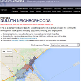 This interactive mapping tool isolates data for preselected boundaries or for custom profile areas chosen by the user.
Duluth is the first city outside of the Minneapolis-St. Paul metro to have access to this powerful data tool, which was developed by the Wilder Foundation with funding from the Northland Foundation, Duluth Superior Area Community Foundation, Head of the Lakes United Way, City of Duluth, and the Ordean Foundation. Some of the features the site offers:
-
Choose from the map views drop-down to see additional maps with key data.
-
Click on a predetermined neighborhood area within the map for details and links to the profiles.
-
Use the interactive mapping tool to create a custom profile, meaning users can outline any area within the map, even just a block or two, and view its data.
-
Access a tutorial.
“There are exciting discussions underway to expand the Profiles data to include other areas of northeastern Minnesota, possibly by school district.” —Erik Torch,
Northland Foundation
“To have this wide range of data on a single website available at the click of a mouse offers organizations serving our communities a powerful new way to inform and improve our work,” said Erik Torch, the Director of Grantmaking at the Northland Foundation.
Watch for more bells and whistles as the build-out of the Duluth Neighborhoods data tool continues through the end of February. Local in-person and webinar trainings to help users make the most of the site are being planned, as well.